Deoghar, often called the “Abode of Gods”, is a significant city in Jharkhand. It is renowned for the Baidyanath Jyotirlinga, one of the twelve sacred Jyotirlingas in Hinduism, making it a major pilgrimage destination.
Geography:
- Located in northeastern Jharkhand, near the Rajmahal Hills.
- Coordinates: latitude- 24.48° N, longitude- 86.70° E
- Total area covered: 2,477 square kilometers
- Altitude: 255 meters above sea level
- Boundaries: Dumka, Giridih, Jamtara and Banka (Bihar)
- Topography: Rocky hills such as Phuljari (750 m) and Teror (670 m) surround the region. The Ajay River flows nearby.
- Climate: Deoghar experiences a tropical wet and dry climate. The climate is characterized by hot summers, moderate monsoons, and cool winters.
History & cultural Significance:
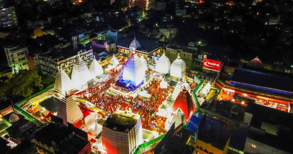
- Home to the famous Baidyanath Temple, an ancient shrine dedicated to Lord Shiva.
- Known for its Shravani Mela, a major annual pilgrimage.
- Deoghar became a municipality in 1869.
- It was part of Santhal Pargana before becoming a separate district in 1981.
Demographics (As per Census 2011):
- Population: 1,492,073
- Sex Ratio: 921 females per 1000 males
- Literacy Rate: 64.85%
- Languages spoken: Hindi, Khortha, Angika, Santhali, Bengali
Administrative divisions:
Deoghar is divided into two subdivisions and ten blocks.
- Subdivisions:
- Deoghar
- Madhupur
- Blocks:
- Deoghar
- Karon
- Madhupur
- Mohanpur
- Palojori
- Sarath
- Devipur
- Margomunda
- Sarwan
- Sonaraithari
- Vidhan Sabha Seats: Deoghar, Madhupur, Sarath
Economy:
The economy of Deoghar district is primarily agrarian, with significant contributions from tourism, trade, and small-scale industries.
- Agriculture: A large part of Deoghar’s population is engaged in agriculture. Major crops grown here are rice, wheat, maize, pulses, and oilseeds.
- Tourism:
- Baidyanath Temple (One of the 12 Jyotirlingas) attracts millions of pilgrims annually.
- Shravani Mela (July–August) brings a huge influx of visitors, boosting local businesses.
- Other attractions like Naulakha Temple, Trikut Hill, Tapovan Hills, and Nandan Pahar support tourism.
- Small-Scale Industries & Handicrafts:
- Cottage Industries: Includes oil extraction, dairy products, and textile weaving.
- Handicrafts: Local artisans produce bamboo crafts, pottery, and Madhubani-style paintings.
Education and healthcare:
- Major Institutions:
- Birla Institute of Technology (BIT), Deoghar – Offers engineering programs
- AIIMS Deoghar – A premier medical institution, started in 2019.
- Ramakrishna Mission Vidyapith – One of the oldest CBSE schools in India (since 1922).
- Healthcare:
- AIIMS Deoghar – Provides advanced healthcare facilities.
- Deoghar District Hospital – Offers general medical services and a blood bank.
Transportation & connectivity:
- Air: Deoghar Airport – Operates domestic flights.
- Rail: Jasidih Junction – The nearest major railway station, well-connected to major cities.
- Road: National Highways: NH 114A, NH 333, and NH 133 provide good road connectivity. Well-connected to Ranchi, Patna, Kolkata, and Bhagalpur.
Tourist Attractions:
- Religious & Cultural Sites:
- Baidyanath Temple – One of the twelve Jyotirlingas.
- Naulakha Temple – Famous for its unique architecture.
- Natural & Recreational Spots:
- Trikut Hill – Offers a ropeway ride and trekking opportunities.
- Nandan Pahar – An amusement park with a lake.
- Tapovan Hills – Known for caves and meditation sites.